


 |
PROJECT
WORKPLAN
Workplan
Structure
Achievement
of the DAMOCLES project’s objectives requires the carrying out of
individual research tasks and the integration of the outputs of those
tasks into an overall product larger than the sum of its components.
To meet this requirement, the work has been divided into five workpackages
closely related to the objectives specified in Section 2. These are:
-
WP1
Development of functional relationships for debris flow behaviour
derived from field data and existing databases.
-
WP2
Development of a GIS hazard assessment methodology using field
data, available databases and model developments.
-
WP3
Development of a small basin debris flow impact model using
field data and a physically based modelling approach.
-
WP4
Application of a physically based, basin scale, landslide erosion
and sediment yield model to land use and climate scenario analysis
for selected sites.
-
WP5
Dissemination of the project deliverables via training courses,
workshops, implementation by end-users and placement of demonstration
material on a web site.
To
understand the methodology for carrying out and integrating these
packages it will be helpful to know the roles and responsibilities
of the DAMOCLES partners. These are identified by participant number,
name and role (CO = coordinator, CR = principal contractor, AC = assistant
contractor, SC = subcontractor, EU = end-user):
CO1
University of Newcastle upon Tyne, UK. Major roles in WP4 and WP5;
minor roles in WP1, WP2 and WP3.
CR2
University of Milan - Bicocca, Italy. Major roles in WP2 and WP5;
minor roles in WP1, WP3 and WP4.
AC3
National Research Council - Institute for Hydrogeological Protection
in Central Italy (CNR-IRPI), Perugia, Italy. Major roles in WP2
and WP5.
CR4
University of Padova, Italy. Major roles in WP3 and WP5; minor roles
inWP1, WP2 and WP4.
CR5
Higher Council for Scientific Studies, Pyreneen Institute of Ecology,
Zaragoza, Spain. Major roles in WP1 and WP5; minor roles in WP2,
WP3 and WP4.
AC/EU6
Geomining Technical Institute, Zaragoza, Spain. Major roles in WP1
and WP5.
SC7
University of Bologna, Italy. Participation in WP2 and WP5.
SC/EU8
Lombardy Region Geological Survey (GSLR), Italy. Participation in
WP2 and WP5.
SC/EU9
Veneto Regional Agency for Environment Protection (ARPAV), Italy.
Participation in WP3 and WP5.
SC/EU10
Autonomous Province of Trento (ASSM), Italy. Participation in WP3
and WP5.
EU11
Land and Urban Planning Directorate, Aragón, Spain. Participation
in WP5 (Not funded by project).
EU12
Interior and Local Administration Directorate, Aragón, Spain. Participation
in WP5 (Not funded by project).
In
addition, all six end-users are providers of data that may be used
in any of the workpackages.
Workplan
Methodology
This
section provides a brief description of the workpackages to indicate
the basic approach, the complementarity of the packages and their
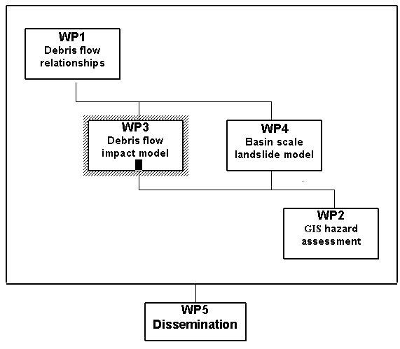
linkages. The Pert diagram in Section 3.3 summarizes the links between
the packages. It should be noted, though, that the links do not necessarily
imply dependence. For example, WP2 will be enhanced by the outputs
of WP3 and WP4 but is not completely dependent on those outputs for
success. Also, while the principal flow of information is from top
left to bottom right, feedback can also occur in the opposite direction.
The workpackages are listed in Table 1 and described in Table 3. The
deliverables are listed in Table 2.
Although
aiming at a general hazard assessment methodology, the work will be
based on three focus areas, both for demonstration purposes and to
make the best use of participant experience and provision of data
by the end-users. Focus area A is in the Pyrenees. Focus areas B and
C are in the Alps.
WP2
is at the core of the project since this will produce the overall
hazard assessment methodology. Its principal demonstration focus area
will be B. Data will be assembled from this area by CR2 (Milan-Bicocca)
and SC/EU8 (Lombardy Region Geological Survey). Data may also be used
from focus areas A and C. A rockfall model will be developed by CR2
and along with the database and results from WP3 and WP4 will be combined
into a GIS modelling methodology by CR2, AC3 (CNR-IRPI) and SC7 (Bologna).
This methodology will be applicable at a range of scales.
WP3
will provide a debris flow impact model, applicable at the small river
basin scale (<10km2). Its principal development and
test focus area will be C but data from focus areas A and B will also
be used. Field data will be assembled by CR4 (Padova), SC/EU9 (ARPAV)
and SC/EU10 (ASSM). The model itself will be developed by CR4 with
emphasis placed on user-friendliness, physical realism and relevance
to practical problems. The model will be available as a stand-alone
code but will also be linked into the hazard assessment methodology
of WP2.
WP4
will make use of an existing but unique physically based, spatially
distributed landslide erosion and sediment yield model, applicable
at basin scales up to 500km2 (SHETRAN). This will be applied
by CO1 (Newcastle) to one site in focus area A and one site in focus
area B or C (the final choice depending on data availability). Data
will be provided by CR5 (Pyreneen Institute of Ecology), AC/EU6 (Geomining
Technical Institute), EU11 (Land and Urban Planning Directorate),
EU12 (Interior and Local Adminstration Directorate) and the relevant
contractor and end-users for focus area B or C. The model will be
applied to give spatial distributions of landslides and debris flows
for a range of land use and climate change scenarios, both as a comparison
with and for input to the hazard assessment methodology of WP2. In
addition it will be used to explore the impact of debris flows on
river basin sediment yield and to develop illustrative guidelines
on land management for minimising debris flow occurrence and sediment
yield impact.
WP3
and WP4 provide important inputs to WP2 which will enhance the capabilities
and reliability of the hazard assessment methodology. In particular
they, along with model developments in WP2, will provide a capability
for both prediction and forecasting of rapid slope failures. The specific
type of forecast which could be considered in the project is the identification
of conditions likely to result in the generation of debris flows within
an area over a limited period of time. The workpackages also complement
each other by enabling debris flow problems to be examined at a range
of spatial scales.
A
major challenge in the DAMOCLES project will be to ensure integration
of the WP3 and WP4 outputs with the requirements of WP2. This will
require close collaboration between CO1 (Newcastle), CR2 (Milan-Bicocca)
and CR4 (Padova) and agreement at the start of the project on data
exchanges, data formats and exact areas of responsibility. The project
quality assurance procedure provides a rigorous standard for the required
management.
WP1
provides for improved understanding of the relationships between debris
flow behaviour and characteristics and environmental variables, including
land use. Data collection, mapping and data analysis will be carried
out by CR5 (Pyreneen Institute of Ecology) and AC/EU6 (Geomining Technical
Institute) for three basins (up to 5500 km2 in total area)
in focus area A. Relevant data may also be used from focus areas B
and C. Relationships linking, for example, debris flow occurrence,
runout distance and volume of material mobilized as a function of
relevant meteorological, geomorphological and land use conditions
will be developed and used to refine the models in WP3 and WP4. It
will be particularly important to be able to model the control on
debris flow occurrence and behaviour exercised by forest cover, in
order to represent the impacts of afforestation and deforestation.
The package will also provide detailed location maps and occurrence
probability maps of rapid slope failures in the focus area, of particular
interest to AC/EU6 (Geomining Technical Institute), EU11 (Land and
Urban Planning Directorate) and EU12 (Interior and Local Administration
Directorate).
WP5
defines the practical aspect of the DAMOCLES project in terms of technology
transfer. It is important that the project should not only advance
our knowledge of rapid slope failures but also put that understanding
at the disposal of end-users. All the participants have important
roles in this package and it will therefore be led by CO1 (Newcastle).
The principal and assistant contractors will provide and transfer
the information, while the project end-users will be the immediate
beneficiaries. Other end-users from outside the project may also be
able to participate in certain parts of the transfer. The main dissemination
procedures are training courses mounted by CR2 (Milan-Bicocca) and
CR4 (Padova), workshops to be led by CO1 and attended by all participants,
demonstration implementations of the models and methodologies in the
relevant focus areas (CO1, CR2, CR4, CR5 and AC/EU6) and the placement
of demonstration results on a web site (led by AC3 (CNR-IRPI) and
involving all participants). End-user advice and needs will be important
in defining these procedures.
Each
of WP1, WP2, WP3 and WP4 involves to a greater or lesser degree the
collection of field data and the use of existing databases. The actual
data required vary between the workpackages and the responsible participants
will therefore manage their own data assembly programmes in each package.
However, experience and expertise will be shared between participants,
partly because the data provision for each package will involve more
than one participant and partly because opportunities will be taken
through meetings to transfer procedures formally. In addition the
project quality assurance procedures will provide standards for recording
data exchange and storage.
Graphical
Presentation of the Project Components (Pert diagram)
Workpackage
list
|
Work-Package
No4
|
Workpackage title
|
Lead
contractor No5
|
Person-months6
|
Start
month7
|
End
month8
|
Deliverable
No9
|
|
WP1
|
Development
of functional relationships for debris flow behaviour
|
5
|
68
|
1
|
30
|
D1,
D2
|
|
WP2
|
Development
of a GIS hazard assessment technology
|
2
|
40
|
1
|
30
|
D3,
D4, D5
|
|
WP3
|
Development
of a small basin debris flow impact mode
|
4
|
81
|
1
|
30
|
D6,
D7
|
|
WP4
|
Application
of basin landslide model to scenario analysis
|
1
|
31
|
1
|
30
|
D8,
D9
|
|
WP5
|
Dissemination
of project deliverables
|
1
|
57
|
1
|
36
|
D10,
D11,D12
|
|
|
TOTAL
|
|
277
|
|
|
|
4
Workpackage number: WP1 - WPn
5
Number of the contractor leading
the work in this workpackage.
6
The total number of person-months
allocated to each workpackage.
7
Relative start date of the work
in the specific workpackage, month 0 marking the start of the project,
and all other start dates being relative to this start date.
8
Relative end date, months 0 marking
the start of the project, and all end dates being relative to this
start date.
9
Deliverable number:
Number for the deliverables(s)/result(s) mentioned in the workpackage:
D1-Dn
Deliverables
list
|
Deliverable
No10
|
Deliverable title
|
Delivery
Date11
|
Nature12
|
Dissemination
Level13
|
|
D1
|
Debris
flow relationships and database
|
21
|
Da
|
REa
|
|
D2
|
Debris
flow maps and mapping procedures
|
30
|
Da
|
REa
|
|
D3
|
Debris
flow and rockfall database for GIS
|
24
|
Da
|
REa
|
|
D4
|
Hazard
and risk assessment technology
|
30
|
Me
|
REa
|
|
D5
|
Review
of rockfall and granular flow models
|
18
|
Re
|
REa
|
|
D6
|
Debris
flow database for impact model
|
15
|
Da
|
REa
|
|
D7
|
Debris
flow impact model
|
24
|
Me
|
REa
|
|
D8
|
Debris
flow impact scenario simulations
|
24
|
Si
|
REa
|
|
D9
|
Guidelines
for basin land management
|
30
|
Me
|
REa
|
|
D10
|
End-users
trained in project technologies
|
36
|
Eub
|
PU
|
|
D11
|
Project
technologies in public domain
|
36
|
Me
|
PU
|
|
D12
|
Proposal
for standard approach to zonation
|
36
|
Me
|
PU
|
|
|
|
|
|
a
Restricted level refers to deliverable as input to another component
of the project. All deliverables will be made
public via deliverable D11.
b
Trained end-user.
10
Deliverable numbers in order of delivery dates: D1 - Dn
11
Month in which
the deliverables will be available, month 0 marking the start of
the project, and all delivery dates being relative to this start
date.
12
Please
indicate the nature of the deliverable using one of the following
codes:
Re
= Report Da = Data set Eq = Equipment
Pr
= Prototype Si = Simulation Th = Theory
De
= Demonstrator Me = Methodology O = Other (describe
in annex)
13
Please
indicate the dissemination level using one of the following codes:
PU
= Public
RE
= Restricted
to a group specified by the consortium (including the Commisssion
Services).
CO
= Confidential,
only for members of the consortium (including the Commission Services)


|