
|
|
|
|
Pioverna Basin
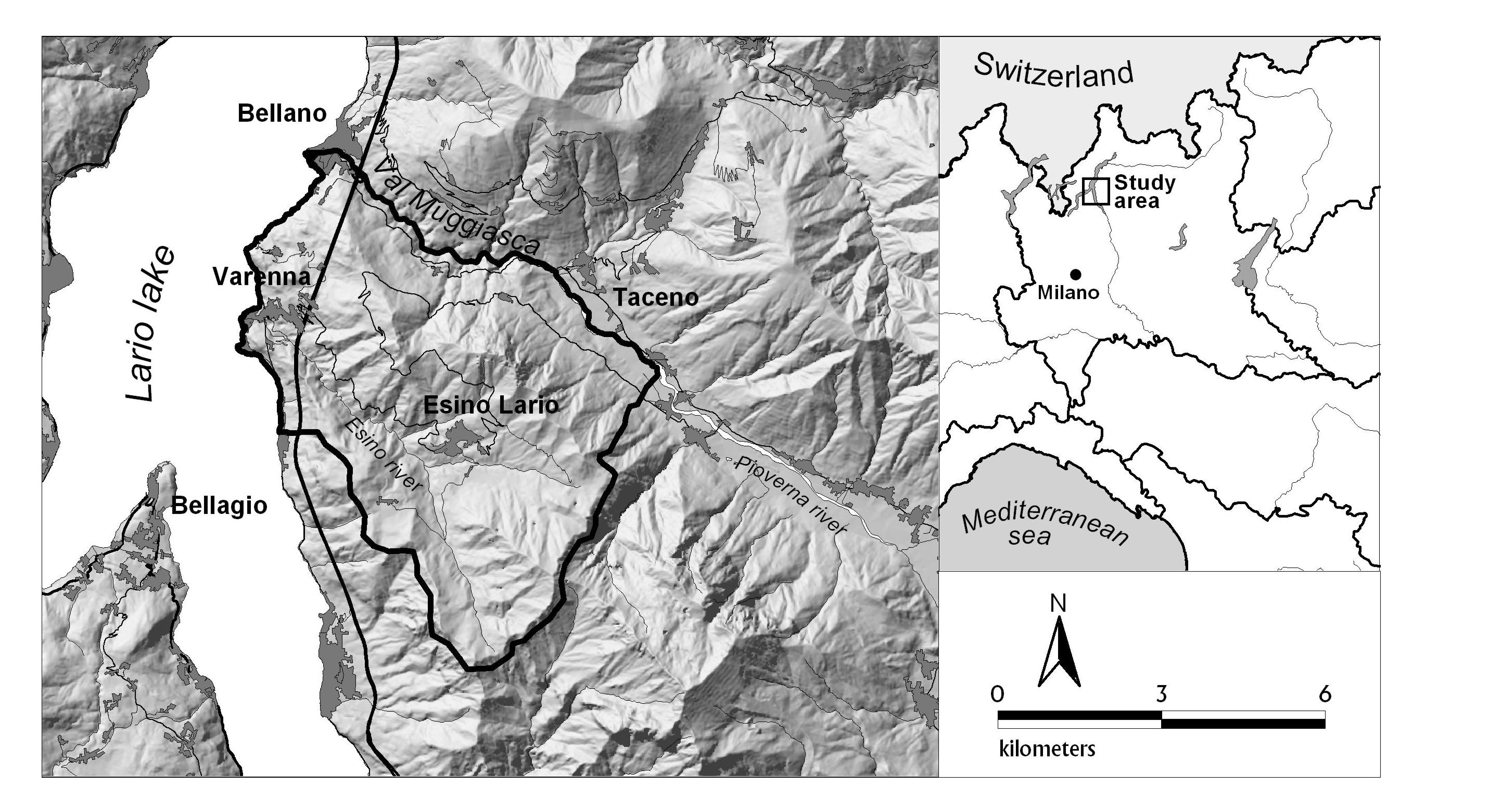
The study area is located on the eastern side of Lario lake (Lombardy Region, Northern Italy) and include the Esino river basin and the southern side of Muggiasca Valley (figure 1). This valley correspond to the lower basin of the Pioverna river basin, from Taceno to Bellano, and adjoin the northern border of Esino basin. The whole study area has an extension of 38 km2 and is situated between 200 m and 1830 m. The mean annual precipitation ranges from 1450 mm in the lower part of the basin, to 1650 mm in the upper part.
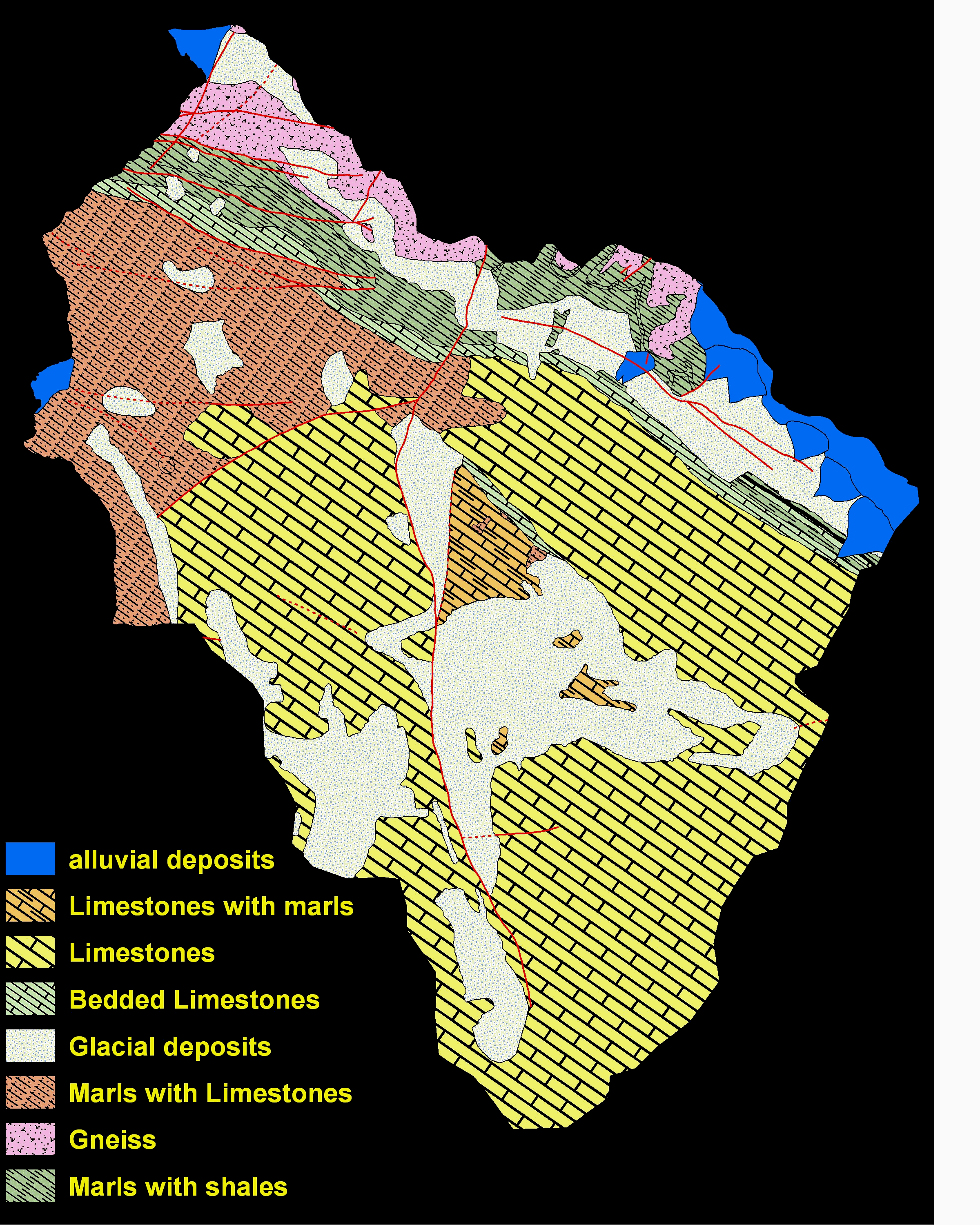
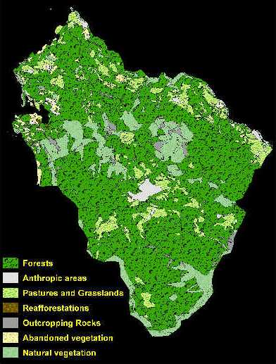
The main portion of the study area is characterised by massive limestones (Esino Fm.), covered and mantled, in the gently sloping areas, with thick glacial deposits. The western part of the area is characterised by well bedded black micritic limestones with unoxydated carbonic matter and some intercalation of very fine tuffitic layers (Perledo Varenna Fm). In the northern part of the area there is a rapid succession of different sedimentary units: well bedded light grey dolomites (Albiga dolomite), thick bedded sandstones and fine conglomerates, with dolomitic intercalations (Bellano Formation), quartzites and quartz fine conglomerates ("Servino") and red and green conglomerates ("Verrucano Lombardo"). These units lie in stratigraphical contact on the top of the basement (Schönborn, 1992) that is composed by gneiss and micaschistes (figure 2). Most of the area is composed by colluvial soils, with a depth ranging from 0.3 to 1.5 m. A large portion of central Esino basin is composed by thick glacial deposits, 1 to 3 m in depth, whereas discontinuous scree slope deposits can be found under the main calcareous scarps. Finally, land-use is primarily forest, with discontinuous meadows around Esino and few terraced areas on the lake-side near Bellano (figure 3).
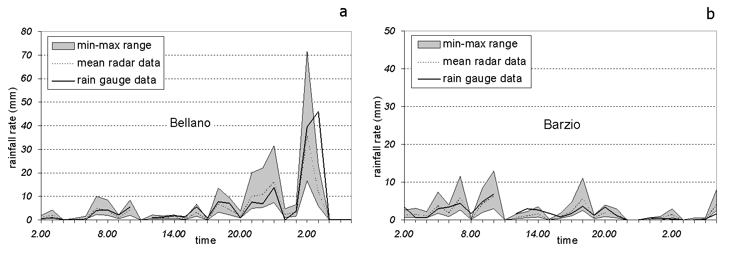
June 27-28, 1997 rainfall Event A short-duration high-intensity rainfall event interested the basin of Esino river on June 27-28th 1997. In less than 2 hours almost 100 mm of rain felt within the study area, triggering many landslides. Rain gauges data and radar images have been used to describe the rainfall event. Rain gauges with hourly records are located in Bellano (202 m a.s.l.), on the north-east edge of the study area and Barzio (755 m a.s.l.), 8 km to the east. Radar data for Mount Lema radar station, 35 km to the west of the study area, were provided by the Swiss Meteorological Institute. Rainfall intensities (R) are estimated from the measured radar reflectivity (Z) with a Z-R relationship, with time interval between measurements of 5 minutes, and with a spatial resolution of 2 x 2 km. In order to correct those factors that affect the accuracy of the estimation, the Swiss Meteorological Institute performs an automatic calibration of the instruments to verify the stability of all important components, a software processing in order to partially eliminate ground clutter, shadowing by mountain ridges and a long-term correlation and adjustment with data from rain gauges (Joss et al., 1997). Radar estimated intensities are classified in 5 classes, making more complicate the comparison with rain-gauges data. Figure 4 shows a comparison of the two sets of intensities for the rainfall event at the stations of Bellano and Barzio. Rain gauge data satisfactory fit the range of values given by radar data, and approximately follow the calculated mean value of radar intensity. This is especially true for the Bellano rain-gauge station. This result supports the use of radar derived rainfall intensities for application in landslide triggering assessment, at least in this special case.
Figure 4. Hourly rainfall data from 2:00 a.m. of the 27th to 6:00 a.m. of 28th June 1997 from Bellano and Barzio rain gauges. 30 minutes radar data from Mount Lema station have been hourly averaged to compare with rain gauge data.
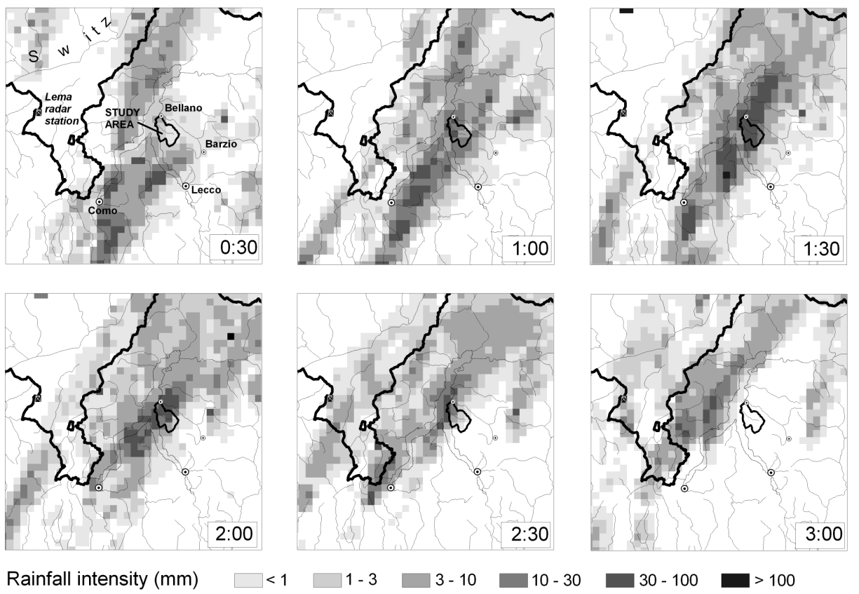
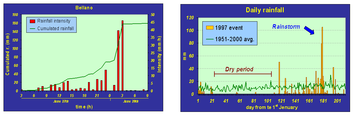
Figure 5. 30 minutes radar sketches of the rainfall event, from 0:30 a.m. to 3.00 a.m. of 28th June 1997. The high intensity-short duration rainstorm hit the study area in the night between 27th and 28th June 1997. The thunderstorm reached the southern part of the study area at 1:00 a.m., moving northerly (figure 5). From 01:30 to 02:30 the rainstorm passed through Bellano, as the rain gauge station correctly recorded with measured intensity of 39 mm/h between 1:00 and 2:00 a.m., and 46 mm/h between 2:00 and 3:00 a.m. (figure 6a). Prolonged low-intensity precipitation characterised the 2 preceding months, with almost 280 mm of rain (figure 6b). Then, even if the days immediately antecedent the event were characterised by moderate rainfalls (50 mm of rain in one week), the initial soil moisture should have been high at the beginning of the high intensity rainstorm.
Figure 6. a) Hourly rainfall intensity and cumulated rainfall from Bellano rain gauge; b daily rainfall data from Bellano rain gauge station from the 1st January to 31st August 1997; the 27th - 28th rainfall event followed a 2-months period of prolonged low intensity precipitation.
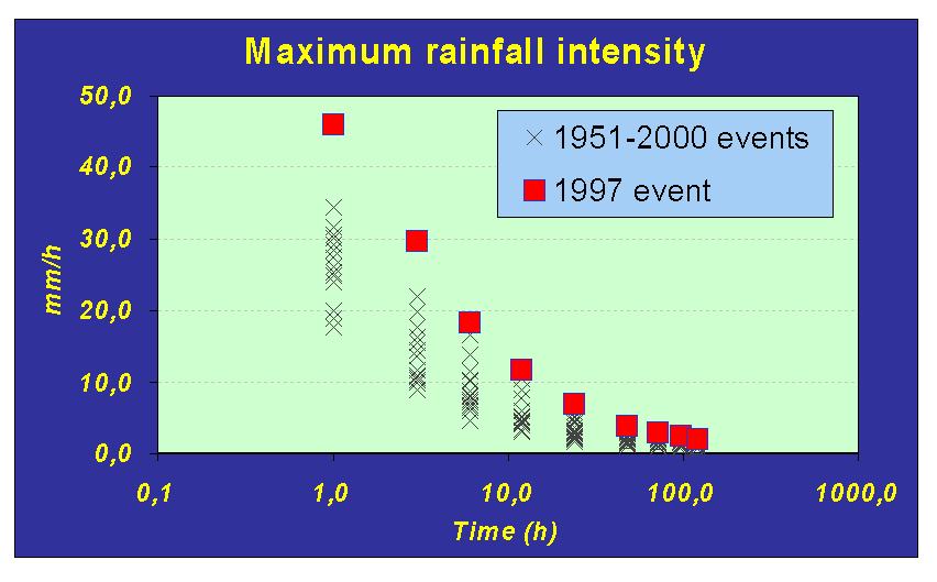
Figure 7. Recurrence time of rainfall events at Bellano rain gauge compared with the 27th - 28th June 1997 even The statistical analysis of historical rainfall data indicates that the event was exceptional if compared with the last 50 years of precipitation, especially for short time duration events. The calculated recurrence time ranges from 75 years for the short time (1 to 2 hours) to 25 years a longer duration time (1 to 23 days) (figure 7).
|